 Telluride, Colo. — As the small twin-engine prop plane circled on final approach to the Telluride (Colorado) Region Airport, I began to get a sense what the next three days would be like.? Located at 9,070 feet above sea level, this is the highest commercial airport in North America, and about 50 yards to the south of the runway, I saw that the mesa drops more than 1,000 feet to the valley below ? frightening and beautiful all at the same time.
The next morning Bob Burns, Land Rover?s chief driving instructor, and the head of our Colorado expedition, began briefing the 16 members of our expedition, telling us we would be driving about 80 miles in two days.? We would be on paved highways for about 15 miles and the rest would be dirt, rock and an occasional stream. ?What he failed to say was that the last couple of miles of the trip we would be dropping about 2,000 feet down the face of a cliff.
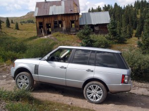
An hour later, I was turning off a paved Telluride street onto Tomboy Road, driving a supercharged 510-horsepower Land Rover Ranger Rover.? Burns explained on the two-way radio that this rough narrow path was originally a stagecoach road cut over the mountain by miners in the late 1880s to haul supplies in and gold and silver out of the San Juan Mountains.
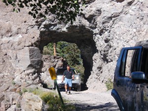 The road climbed up the side of the mountain, passing through an occasional tunnel cut through the rocks and providing spectacular views of the Telluride Valley below Bridal Veil Falls. ?At the recommendation of the Land Rover driving instructor assigned to me, I turned the Range Rover?s Terrain Response? dial to the ?Grass-Gravel-Snow? setting, which was designed for firm surfaces with a coating of loose materials like the gravel we were experiencing. ?This automatically raised the ride vehicle height for better clearance, shifted to low range and switched on the Hill Decent Control system.
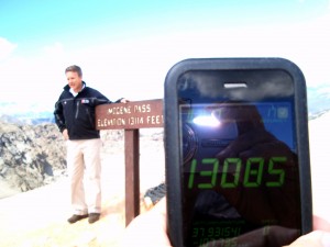 Tomboy Road was like a time machine, leading us through the ruins of mining camps and fields of ore tailings that more than 100 years ago produced millions of dollars worth of gold and silver. (That doesn?t seem like much now, but remember gold was $21 per ounce then and today it?s over $1,300 per ounce.) ?After a couple of hours bumping up the rocky road, traversing rocks and climbing up a few steep sections, the ten Land Rovers reached the saddle of Imogene pass.? At 13,114 feet elevation, we had a panorama of mountain peaks and a view of Telluride about 4,300 feet below.
The shinny Land Rovers with their posh leather, wood and aluminum interiors were a stark contrast to the rocky, treeless mountain.? The vehicle was so comfortable and easy to drive; it made me almost feel like an armchair spectator to the adventure.
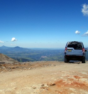 We paused for a half hour to soak in the view, stare down at where we had been and drink more water.? At this altitude, not consuming mass quantities of water can lead to dehydration and altitude sickness.
Moving down long steep slopes on the northern side of Imogene pass, we stopped beside a creek for lunch under the watchful eyes of several deer.? Then it was a downhill run on better dirt roads through Camp Bird and Thistledown to our destination of Ouray and a night in the historic Beaumont Hotel.
The Beaumont opened in 1887 during the height of the Colorado gold boom and was the social and business hub of the area.? After being boarded up for more than 35 years, it was purchased at auction and went through a five-year restoration returning it to its original elegant state, including furnishings, wallpaper patterns and carpeting.? Owners Dan and Mary King did add modern conveniences like air conditioning, television and wireless Internet service to make the 12 rooms more comfortable for modern travelers when it reopened in December 2003.
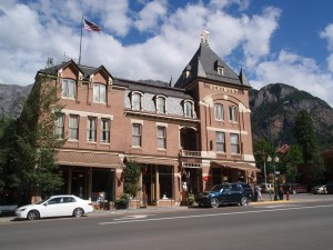 At its prime, the Beaumont played host to travelers like Theodore Roosevelt, Herbert Hoover, Sarah Bernhardt and King Leopold of Belgium.
After drinks in the Voodoo Lounge and an excellent dinner in the Tundra dining room I retired for a good night?s sleep.
For the second part of our adventure, I switched to the new Land Rover LR4, powered by a 375-hp, 5.0-liter V-8.? This mid-level model has nearly all the same drivetrain features as the flagship Range Rover I had driven the day before, but it?s not quite as luxurious.? Of course, luxurious is a relative term, and the LR4 is still nicer and more capable than nearly any other SUV on the trail or the road.
Day two started with our Land Rover caravan driving south out of Ouray on the Million Dollar Highway, which was originally a toll road built in 1883 to reach the mining districts around Red Mountain pass between Ouray and Silverton.? In typical Land Rover style, we quickly exited the paved road onto the Alpine Loop, which was essentially a back road to Silverton.
After a few hours of challenging Alpine Loop roads we arrived in Silverton for an excellent lunch at the Handlebars Restaurant.? The popular restaurant was packed with tourists who had just arrived on the D&SNGRR (Durango & Silverton Narrow Gauge Railroad) that goes back and forth each day between Durango and Silverton.
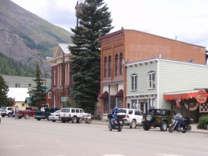 Sitting in a valley at 9,305 feet above sea level, Silverton is the product of the miners and ?sturdy souls? who ran the businesses and services used by the miners.? This was a difficult place to live, especially in the harsh winters.? The cemetery documents extensive deaths from snow slides, consumption, pneumonia, influenza and most of all mining accidents.
Leaving Silverton, we drove a few more miles on pavement, going north this time, on the Million Dollar Highway to Red Mountain Pass, elevation 11,018 feet.? Turning off the pavement on to Black Bear Pass the first thing you see is a sign that reads:
Telluride
City of Gold
12 miles ? 2 Hours
You don?t have to be crazy
to drive this road ? but it helps.
?
Jeeps Only
In the world of off-road vehicles, Jeeps are King, but the Land Rovers are even better.
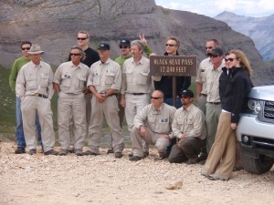
After a short steep drive, we reached the top of Black Bear Pass at the 12,840 foot level and stopped to take photos of the group before starting our decent into Telluride, just over 4,000 feet below.
I started down the hanging valley on the road, which is labeled ?One Way?.? I?m used to one-way streets in cities, but don?t expect this type of traffic control on a mountaintop.? However, as I would soon see, that the road is cut back and forth across the steep face of a mountain, and there is barely room for one vehicle, let alone two.? One day each summer, the direction is reversed for an annual Jeeper?s Jamboree, however.
Initially, the road parallels Ingram Creek as it flows toward the end of the hanging valley.? Suddenly, the valley disappears and I am on the edge of a cliff looking down more than 2,000 feet toward Telluride.? The road drops over the edge and becomes a narrow pathway cut into the side of a steep rock covered cliff.? As if that?s not scary enough, the path?s surface is covered with loose rock.? Now I?m hoping that the improvements to the Terrain Response system are as good as they say.
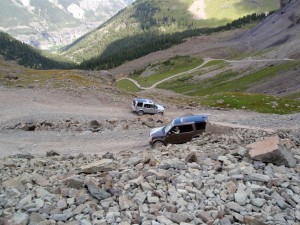 The 2011 Land Rover Terrain Response system is equipped with a new Hill Start Assist and Gradient Acceleration Control.? Right now, the Hill Start Assist isn?t as important, but the Gradient Acceleration Control could be a big help on the steep slippery path.? It?s a safety device that activates on severe inclines when the Hill Descent Control is not engaged.? It pressurizes the brakes to slow the vehicle to a speed limit determined by throttle position when descending a slope in Drive or Reverse.? If for example, I accidently canceled the Hill Descent Control, this would restrict speed to no more than 3 mph for 20 seconds, thereby allowing me to re-gain control.
As I inch my way down the steep path it?s a dangerous balancing act.? Get too close to the hill, and I scrape the vehicle and possible cause rocks to fall, or get too close to the downhill side and have a tire slip off, which could send me on a thousand foot drop and likely death. (I did read earlier that the last deaths on the pass were in 2004.)
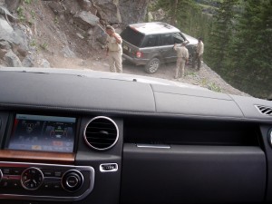 At the end of the first leg, the LR4 needs to be turned 180 degrees on a very small rocky ledge.? This is where the driving instructors are invaluable in spotting how far I can go before having to back up.? The sharp 37.6-foot turning radius of the LR4 is a big help, too.? That?s one sharp hairpin turn down and eight to go. ?Some turns are so sharp it?s necessary to back up a couple of times to make the turn.
A fear of heights is out of the question on this trip.? When I was on the downhill side of the vehicle, I was looking straight down onto one of the other Land Rovers below me.? There would be no place for me to stand, if I had to get out of the vehicle ? the path is so narrow, the tires on the downhill side are just inches from the edge.
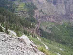 However, the view from the face of Black Bear Pass was amazing as I actually looked down on the 365-foot high Bridal Veil Falls and the house with the electric generating plant that sits on a rock next to the falls.
With the mountain goat like surefootness of the LR4, I zigzag my way down the 2,000-foot cliff.? At the bottom, I am reminded of what my friend David Schmidt, a fellow auto writer, says each time he gets out of a car — ?We cheated death again!?
On a recent trip to Southern California I was in awe at the number of Land Rovers on the streets, especially the high-end Range Rover models.? I wonder if those people realize what their vehicles can actually do.


